File:Map of Vardar river basin-bg.svg
Jump to navigation
Jump to search

Size of this PNG preview of this SVG file: 490 × 599 pixels. Other resolutions: 196 × 240 pixels | 392 × 480 pixels | 628 × 768 pixels | 837 × 1,024 pixels | 1,674 × 2,048 pixels | 1,800 × 2,202 pixels.
Original file (SVG file, nominally 1,800 × 2,202 pixels, file size: 7.62 MB)
Captions
Captions
Add a one-line explanation of what this file represents
Summary[edit]
| Description |
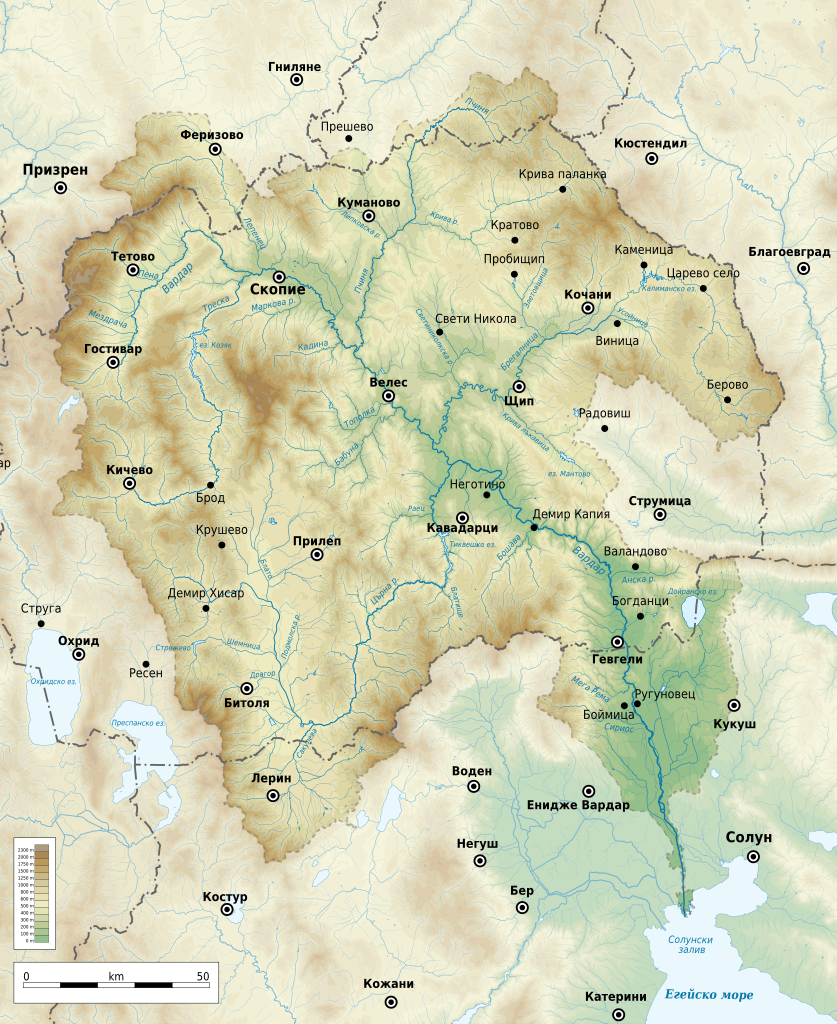
English: Geographic map of Vardar river basin in Bulgarian. Geographic limits of the map:
English: Географска карта на водосборния басейн на река Вардар на български. Граници на картата:
|
| Date | |
| Source |
Own work
|
| Author | Ikonact |
| Permission (Reusing this file) |
Any use of this map is subject of the license(s) stated below with the condition that you credit (Wikimedia Commons user: Ikonact) as the author . A message with a reply address would also be greatly appreciated. |
| Other versions |
|
| SVG development |


Licensing[edit]
I, the copyright holder of this work, hereby publish it under the following license:
This file is licensed under the Creative Commons Attribution-Share Alike 4.0 International license.
- You are free:
- to share – to copy, distribute and transmit the work
- to remix – to adapt the work
- Under the following conditions:
- attribution – You must give appropriate credit, provide a link to the license, and indicate if changes were made. You may do so in any reasonable manner, but not in any way that suggests the licensor endorses you or your use.
- share alike – If you remix, transform, or build upon the material, you must distribute your contributions under the same or compatible license as the original.
File history
Click on a date/time to view the file as it appeared at that time.
| Date/Time | Thumbnail | Dimensions | User | Comment | |
|---|---|---|---|---|---|
| current | 20:32, 26 April 2021 | | 1,800 × 2,202 (7.62 MB) | Ikonact (talk | contribs) | css fix for translation |
| 20:23, 26 April 2021 |  | 1,800 × 2,202 (7.62 MB) | Ikonact (talk | contribs) | valid svg | |
| 21:39, 16 February 2021 |  | 1,800 × 2,202 (7.97 MB) | Ikonact (talk | contribs) | basin corr | |
| 21:31, 16 February 2021 |  | 1,800 × 2,202 (7.97 MB) | Ikonact (talk | contribs) | + more lakes and lowest level rivers | |
| 13:51, 12 February 2021 |  | 1,800 × 2,202 (6.62 MB) | Мико (talk | contribs) | correction | |
| 13:44, 12 February 2021 |  | 1,800 × 2,202 (6.62 MB) | Мико (talk | contribs) | corr | |
| 22:36, 11 February 2021 |  | 1,800 × 2,202 (6.62 MB) | Ikonact (talk | contribs) | + river names | |
| 21:59, 10 February 2021 |  | 1,800 × 2,202 (6.58 MB) | Ikonact (talk | contribs) | {{Information |description={{en|1=Geographic map of Vardar river basin in Bulgarian. Geographic limits of the map:}} {{en|1=Географска карта на водосборния басейн на река Вардар на български. Граници на картата:}} *N: 42.64° N *S: 40.25° N *W: 20.55° E *E: 23.20° E Equidistant Cylindrical projection; WGS 84 datum |date=2021-02-10 |source={{own}} *Sources of data:<br/> **Topography: SRTM3 v4 (public domain);<br/> **Rivers and water bodies: Produced using Copernicu... |
You cannot overwrite this file.
File usage on Commons
The following page uses this file:
File usage on other wikis
The following other wikis use this file:
- Usage on bg.wikipedia.org